For those of you who aren't Backwell residents, this is what Wikipedia says about Backwell:
Backwell is a rural village and civil parish in Somerset, England. It falls within the Unitary Authority of North Somerset and has a population of 5,455. It is 7 miles (11.3 km) south west of Bristol, on the A370 to Weston-super-Mare.
Here's a brief history taken from the draft Backwell Neighbourhood Plan:
A brief history of Backwell. Backwell is mentioned in the Domesday Book of 1086. In the 18th century the parish comprised the hamlets of Church Town, Farleigh, West Town, Downside and Moorside (Backwell Common). The oldest settlement is Church Town. St Andrew’s Church dates from the 14th century. The road from Farleigh to Church Town to West Town was the medieval highway. The track from Farleigh to West Town was improved in the 18th century and is now the A370. Most of the modern housing was constructed in the period 1950-80.
In the post-war period these hamlets, with the exception of Downside, gradually coalesced via a combination of ribbon development along the main highways and infilling, to form the main built-up area of the village. Each hamlet still retains something of its original identity, partly because of the distance between them: from the edge of West Town to Farleigh is around one and a half miles, and from Church Town to Moorside (the Station) is around a mile. This distance also makes the average length of journeys within the built-up area longer than would be expected for a village of Backwell's size of population.
The current local and county development plans envisage little further residential development, although at least one major housebuilding company is known to own a parcel of land in the village.
The main A370 passes through the village. For better or ill, Backwell was never bypassed (unlike Long Ashton) and hence suffers considerably from through-traffic between Bristol and Weston-Super Mare.
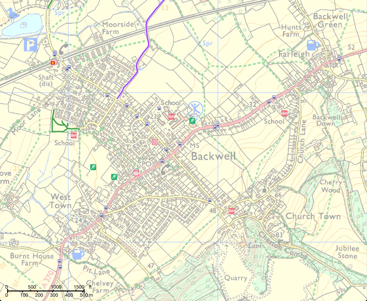
The other main road axis within the village runs at 90 degrees to the A370, with the roads bisecting at the crossroads next to the village hall. To the south of the A370 is Dark Lane, to the north (heading towards Nailsea) is Station Road. Here's a map:
All of these roads are severely congested, particularly at peak times, and present considerable dangers to cyclists, especially inexperienced ones. Whilst much of the A370 is relatively wide, and could accommodate segregated or shared-use cycling facilities on at least one side of the road (with a few width challenges in places), Station Road and, to a lesser extent, Dark Lane present much greater engineering challenges due to their very narrow width along much of their length.
Backwell does have two major advantages, however. The first is that it is relatively flat, with the ground only rising to a noticeable extent as you go along Dark Lane towards Church Town. The second is that there remain, between the four hamlets, large areas of undeveloped land, either farmland, or playing fields, which could potentially accommodate safe cycling and walking routes for people to move around the village avoiding the A370 and Station Road/Dark Lane.
Neither advantage has, to date, been exploited and Backwell remains almost completely devoid of any such safe routes, even as other nearby communities such as Nailsea, Long Ashton and Clevedon are busy adding to theirs. It is understood that there have been some attempts to establish a safe route from Station Road to Chelvey, avoiding the A370, although there seems to be no immediate prospect of such a route being built.
It is to be hoped that the Backwell Neighbourhood Plan, called 'Backwell Future', will, once finalised and adopted, offer a springboard to develop such infrastructure - ideally in the form of a proper network of well-signed, well-surfaced shared-use paths - over the 14-year lifetime of the Plan (to 2026).
OK, back to the present day.
Our tour starts at the village crossroads (A370/Station Road/Dark Lane). You may have missed it, but there is a 20 yard stretch of on-road cycle lane as you approach the crossroads heading towards Bristol (Exhibit 1). Here it is:

Sadly the painted lines and bike symbol have become so worn by passing traffic that they are barely visible. Rather a strong sign that the cycle lane was being routinely ignored by drivers. This cycle lane feeds into an advanced stop line ('ASL'), a better picture of which is below (again, being ignored by this driver):

At least the road width here actually allows cyclists to access the ASL, unlike the ones on Station Road and Dark Lane. Want to try to filter alongside cars on those roads? Good luck with that. Anyhow, the four ASL's at the crossroads go on the list as Exhibit 2.
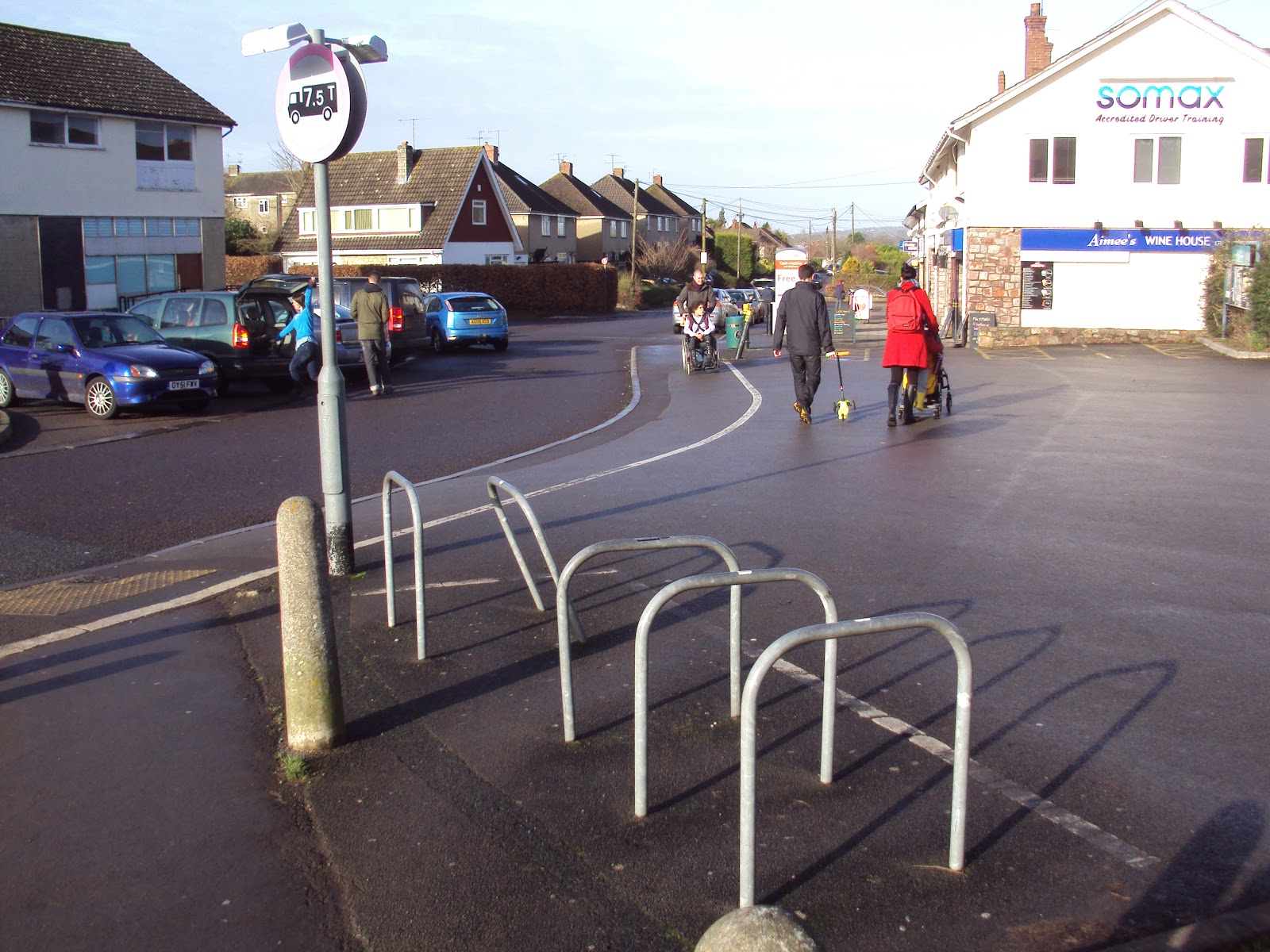
You have to hunt around a bit to find the next bit of infrastructure. Here we have some bike racks at the village centre shops on Rodney Road (Exhibit 3). One of which seems to have suffered at the hands of a reversing driver, but hey, it's still just about usable:
There are also some bike racks at the doctor's surgery (Exhibit 4):

....and at the Station, where a total of 38 bikes can be accommodated in two discrete shelters. Unusually, two car parking bays were sacrificed to make space for this one (Exhibit 5):

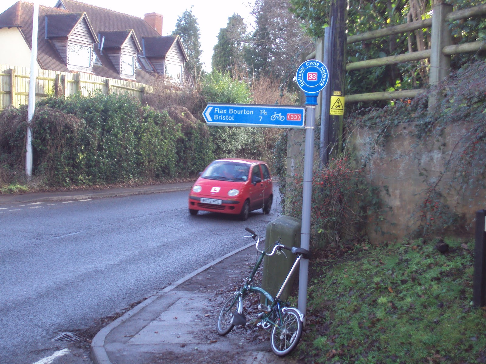
I suppose I should also include the signage to the National Cycle Network at the junction of Station Road and Backwell Common, although I'm not sure whether this counts as infrastructure. Nice colour though (Exhibit 6):
Sustrans' online route mapping shows the paths around the Moor Lane play area as cycle paths, although they aren't actually signed as shared-use and are a little narrow so probably don't count, but I've included them anyway (Exhibit 7):

There is one superb bit of infrastructure which is tantalisingly close, but really belongs to Nailsea. I'm including it here as an example of what is needed, and what can be achieved where planners and councils put their minds to it. This is on Station Road, at Bucklands Batch on the edge of Nailsea. Sadly it is only around 50 yards long before it stops abruptly and forces cyclists back out into the main carriageway - a feature of too much cycling infrastructure in the UK sadly.

That's more or less it. To the extent that there is any more infrastructure, and I have missed it, let me know. There is what I would describe as some 'anti-infrastructure' in the form of 'No cycling' signs. The picture below could be taken as a symbol of Backwell's current predicament, really.....

If you would like to change this, please join us by emailing peterrogers2@sky.com and in the meantime 'liking' our facebook page at www.facebook.com/backwellSTAG
In a future post I will look at how well (or otherwise) Backwell provides for pedestrians and those with mobility problems.
No comments:
Post a Comment